Skip to search
Skip to main content
Digital Commonwealth
Sign Up / Log In
Search for
Search
Search
Search
Basic
Advanced
Explore
Map
Collections
Institutions
Formats
For Educators
Primary Source Sets
Lesson Plans
Using Primary Sources
Searching Digital Commonwealth
For Institutions
How to Contribute Collections
Digitization Services
Frequently Asked Questions
Collection Development Policy
About
About Digital Commonwealth
News & Announcements
Copyright & Terms of Use
Harmful Content Statement
Partners
API
Contact Us
Williams College
Hopkins Forest Map Collection
Northeastern Hopkins Memorial Forest map
View this item online at Williams College
Item Information
Title:
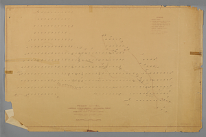
Northeastern Hopkins Memorial Forest map
Description:
Primary Control Lawrence Hopkins Memorial Forest NEFES File No. X-143 (with survey elevation notations in ink). 1:4800. Permanent plot elevations in ink; water lines to USFS facilities penciled in.
Collector:
Art, Henry Warren
Creator:
United States Forest Service
Date:
1936
Format:
Maps/Atlases
Location:
Williams College
Collection (local):
Hopkins Forest Map Collection
Subjects:
United States. Forest Service--Boundary lines
Link to Item:
https://williams.alma.exlibrisgroup.com/discovery/delivery/01WIL_INST:01WIL_SPECIAL/12287976160002786
Terms of Use:
Contact Archives and Special Collections at archives@williams.edu
Contact host institution for more information.
Language:
English
Identifier:
hopkinsforestmaps:146
show more...
View MODS XML
More Like This
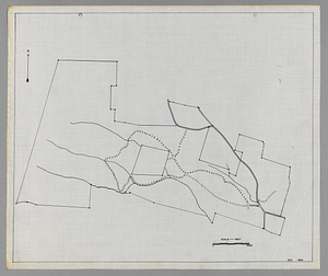
Lawrence Hopkins Memorial Experimental Forest outline boundary map
Lawrence Hopkins Memorial Experimental Forest outline boundary map
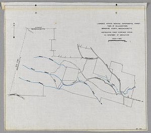
Northeastern Hopkins Memorial Forest map
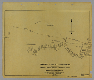
Old Petersburg Road map
Find More Like This >>
Tools
Share
Facebook
Pinterest
X
Reddit
Tumblr
Email
Copy link
Add to Folder
Questions/Comments
Cite This Item